


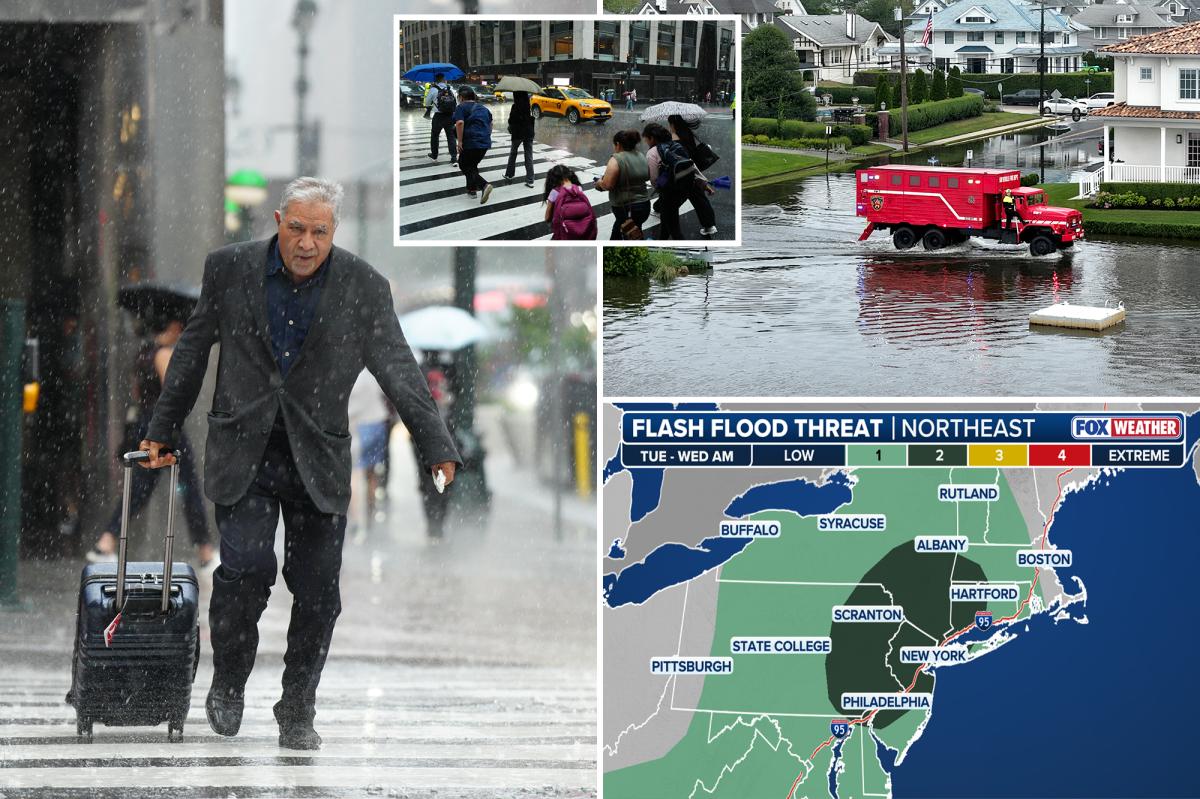
The FOX Forecast Center is monitoring the next storm system moving into the Northeast, carrying threats far beyond severe weather.
Arriving Tuesday through Wednesday, the system is set to bring yet another heightened flash flooding risk along the I-95 corridor, alongside strong, gusty winds along the coast.
“Unlike some of the previous storms to impact the Northeast this summer, this particular storm system is expected to take a more southerly trajectory, placing an area of low pressure squarely in the Lower 48,” the FOX Forecast Center said.
The main area of low pressure will begin to consolidate during the day Tuesday in parts of New England.
As the low strengthens, it will produce widespread storms surrounding the center and extending all along a cold front stretching back across the Appalachians.
While most of the rain associated with the low pressure will remain sub-severe, the incredible amount of moisture in the atmosphere will make for higher rain rates.
Flash flooding could quickly become a problem, especially as the low gets closer to the East Coast by Tuesday evening.
Furthermore, an even greater flood threat will begin to take shape closer to the I-95 corridor as the system creeps in.
According to the FOX Forecast Center, “The storms that form along the front to the south of the low could have rain rates that exceed 1 to 2 inches per hour.”
A Level 2 out of 4 flash flood threat currently encompasses parts of the Lower Hudson Valley, New York City and areas as far south as Philadelphia.
In this zone, storms could repeatedly train over the same region, which will quickly create flooding issues for the Tuesday evening commute.
To complicate matters, a secondary area of low pressure may form just off the coast near Long Island or just inland.
Not only could this low enhance rain rates, it could also trigger strong winds and coastal flooding from Long Island to Down East Maine.
This secondary low will start to form sometime Tuesday evening into Wednesday morning, with winds potentially gusting as high as 40 to 50 mph in some locations.
As it forms, it will push north back into New England and rotate around the original, larger low.
This shifts the flood threat with it, pushing Wednesday’s Level 2 out of 4 risk into Hartford, Boston, Concord and Maine.
Combined, Tuesday and Wednesday’s rain totals could surpass 3 to 5 inches.
That said, the greatest flood threat zone may shift, or be upgraded, as confidence increases regarding how the evolution of the secondary low plays out.
The FOX Forecast Center highlights that, contrary to what some have said, this is not expected to be a July nor’easter because the winds are generally out of the south.
“Regardless of the classification of this system, many of the impacts could be compared to a Nor’easter. Rain will be heavy at times, the duration of the rainfall could be extended, and the winds may cause coastal flooding issues,” the FOX Forecast Center said.
Read the full article here