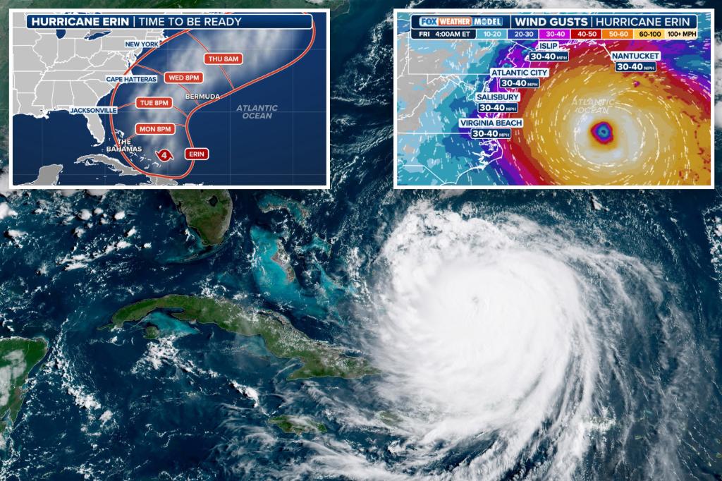
Hurricane Erin will bring “monster” waves to the East Coast as a powers through the Atlantic — even though its path is almost certain to stay far off shore.
Erin — the first hurricane of the 2025 Atlantic season — was spinning as a Category 4 storm with sustained winds of 140-mph north of the Turks and Caicos Monday afternoon, and is expected to veer northward as the week continues.
The storm will skirt outside the Bahamas, then cut between the US and Bermuda as it turns to the northeast and heads up the East Coast and out to sea.
But that cut will bring the storm dangerously close to North Carolina Wednesday night into Thursday morning — with forecasters warning the sheer power of the outer bands of the cyclone could send waves up to 20 feet high crashing into the vulnerable reaches of the Outer Banks.
“There’s going to be monster waves, strong winds up and down the coast,” said Fox Weather Meteorologist Cody Braud. “That’s where the worst hit will be.”
“I would expect wave heights into the coastline in the 10 to 20-foot range, especially as you get closer to Cape Hatteras or the Outer Banks of Carolina,” Braud said.
The spaghetti models predicting the storm’s path all now show it will not come near shore.
Those massive waves prompted a state of emergency in North Carolina Sunday in preparation for the storm’s arrival, with Hatteras Island — the easternmost reach of the Outer Banks — and nearby towns being placed under mandatory evacuation orders over fears they could be washed out to sea.
Most evacuation orders come into effect Tuesday morning.
The storm will bring winds up to 50-mph with some gusts reaching 60-mph in North Carolina, and while rain will fall, it isn’t expected to be enough to cause flooding and will be more of an “afterthought” compared to the wave dangers, according to Fox Weather.
The rest of the East Coast will also be lashed by waves large waves, though not to the degree North Carolina will.
Florida can expect waves between 6 and 9-feet, and even as the storm turns northeast and heads out to sea Thursday into Friday it will still hurl waves between 10 and 12-feet at New York and New England.
Those dangerous conditions — even with the storm raging hundreds of miles from shore — show just how catastrophic Hurricane Erin is.
New York City and inland areas are unlikely to experience any major effects from the hurricane, Fox Weather predicted.
“I have a suspicion most people probably won’t even notice it,” Broad said, explaining the most anybody in the city will notice are slightly gusty winds.
When Hurricane Erin first formed as a tropical storm a week ago on Aug. 11, there were fears it might barrel into the US on a westward track instead of turning northeast and skirting along the east coast.
But Fox Weather said there is no chance of that happening anymore, and that there was a “near zero” chance that the hurricane will make landfall anywhere.
Read the full article here


